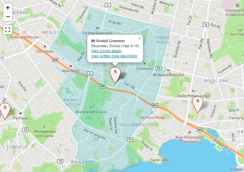
In Zone street description
Starting from where Clifton Road meets the Manukau Harbour, travel south west along the coastline and travel cross country to the west of Waikowhai Road (excluded) to the intersection of Hillsborough Road (279 – 427, 274 – 384 included) and Quona Avenue. Travel north along Quona Avenue, west along Albrecht Avenue, and south west along Glass Road.
Travel north along Revel Avenue, west along Morrie Laing Avenue and north to Richardson Road (569 – 719, 504 – 750 included). Travel west along both sides of Richardson Road to the roundabout at the intersection with Dominion Road Extension (excluded). Continue north west along the centre of Richardson Road and north east along May Road to Stoddard Road. Travel west along Stoddard Road (106, 137 and below included) and then north along Denny Avenue (William Blofield Avenue included). Travel north along May Road and west along Gifford Avenue. Travel north along Elphinstone Avenue and cross country to the intersection of Mt Albert Road (256 – 560, 251 – 563 included) and Sandringham Road (excluded).
Travel south east along Mount Albert Road (Columbia Road, Huntingtree Avenue, Kiwitea Street excluded), north along Renfrew Avenue (excluded) and east along Invermay Avenue (included). Travel south along Dominion Road (823, 928 and above included), east along Kings Road to Parau Street (included). Travel south on Parau Street and east along Duke Street to Mount Eden Road (925, 832 and above included). Travel south along Mt Eden Road (Kingsway included) and continue south along Warren Avenue (Haughey Avenue and Carr Road included), south along Hayr Road, Olsen Avenue and south along Eaton Road.
From the end of Eaton Road, travel cross country to the intersection of Hillsborough Road and Richardson Road. Travel south to Clifton Road, and travel south along Clifton Road (both sides included), back to the starting point.


